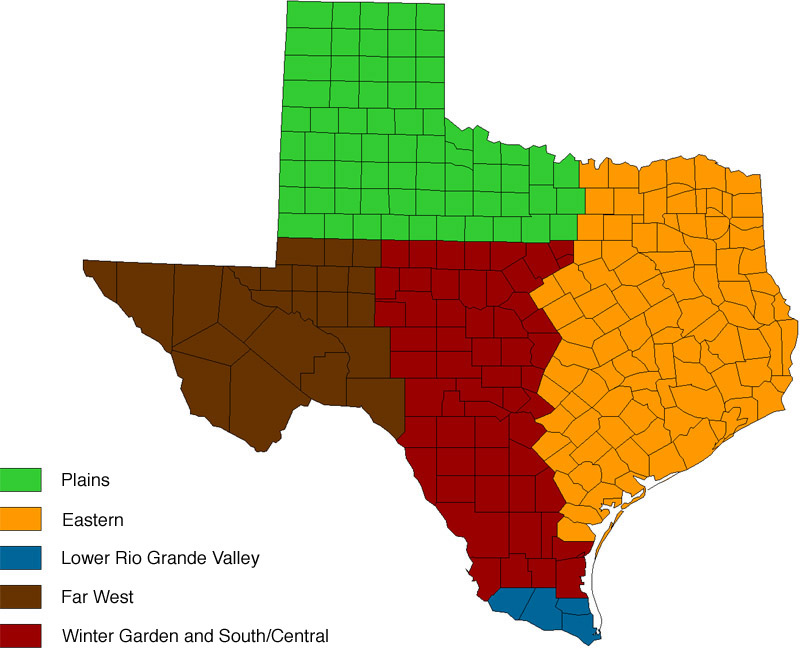
For purposes of this report we consolidated the detailed districts used by TASS/TDA, FSA, and TCE. Regions are discussed and shown in a map.
Lower Rio Grande Valley. Major vegetable region in the state; includes the four southern most counties. Alluvial soils along the Rio Grande River, subtropical environment with 340 frost-free days, irrigation water from canals or wells along the river. A wide diversity of crops for fresh and processing markets, including citrus and early season vegetables for early market windows and agronomic crops of cotton, grains, sugarcane, and other crops. Intensive pest pressures nearly year round.
Winter Garden and South/Central. Includes the Winter Garden and Uvalde area, an intensive irrigated region west and south of San Antonio and the Hill Country. Extends northward to Abilene and southward to the Lower Rio Grande Valley. Diversified dryland and irrigated crop production (Edwards Aquifer) inter-dispersed in the vast rangeland and beef production areas.
Plains Region. Includes northern Panhandle (Amarillo, north to Oklahoma) and South Plains (Lubbock, south to Big Spring), with vast dryland and center pivot irrigation production (Ogallala Aquifer). Clayey soils to the north and generally sandy soils to south and east. Includes eastward Rolling Plains along the Red Riverto I-35 and south to I-20 and Abilene, with dryland production and with some pockets of irrigation. Region varies from 2,000 to 4,600 feet elevation; 26 inches of rain on the east to 16 inches on west at the NM border and growing seasons from 160 to 240 days. Grains, cotton, and oil seed crops predominate but major acreages of horticultural crops.
Eastern Areas. Includes East Texas; typified by sandy soils, small farms and family operations with intensive crop production and numerous cow-calf/pasture operations. Bordered by I-35 on west and OK and LA on north and east and extends southward to Beaumont and Upper Gulf Coast, south to Houston, Corpus Christi, and Coastal Bend region. Good seasonal rains but irrigation is common. Humid summers, long growing season, and close proximity to rural roadside and major metro markets.
Far West Texas. Includes Trans Pecos region (Del Rio, north on US 277) and west to El Paso, with arid lands in the upper Chihuahuan Desert and Desert Grasslands; sparse rainfall (10 inches or less) but intensive crop production where irrigation water is available from the Rio Grande and Pecos Rivers. Crops include cotton, grains, and intensive vegetable and other horticultural crops on alluvial soils in a high desert environment. Production systems are similar to those in NM and AZ.
